

Morocco has recently found itself grappling with the effects of Hurricane Bernard, which has left the country feeling the heat both figuratively and literally.
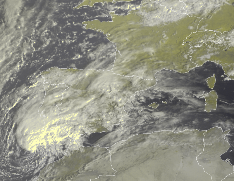
The Hurricane is currently making its way towards the Strait of Gibraltar, causing adverse weather conditions and severe storms across cities in Morocco and southern Europe.
The unexpected arrival of this powerful tropical storm has caught many off guard, as it is an uncommon occurrence for the region.
According to a report from Persia Digest, the deep vortex of low pressure rapidly crossed the Atlantic Ocean and is now approaching the Strait of Gibraltar with a minimum strength of 990 hPa.
As of the latest reports, Hurricane Bernard has already made its presence felt, with gusty winds reaching speeds of up to 100 kilometres per hour (km/h) off the northwest coast of Morocco.
The nucleus of the most severe weather conditions associated with this hurricane is located in its northern outskirts, resulting in intense showers and thunderstorms that are pouring into the open sea.
However, over the next few hours, these weather conditions are expected to reach southern Portugal, leading to extreme adverse weather conditions in the Algarve region.
The effects of Hurricane Bernard are not limited to Portugal and the southern part of the Iberian Peninsula. Heavy rain and thunderstorms are forecast to move into western Spain by this evening.
The pattern is expected to continue during the night in the northern regions of the Iberian Peninsula and then reach the Bay of Biscay.
On Monday, the storm is set to cross France, leaving a trail of rain and showers in its wake. The Atlantic coasts of Morocco will also experience rain and showers in the coming hours.
Along with heavy rain, strong winds are a significant concern. Southwest winds with speeds of up to 100 km/h have been sweeping the Strait of Gibraltar, leading to storms on the Portuguese coast, the southern coast of Spain, and the Atlantic side of Morocco.
In addition, strong southerly winds are expected during the following night in the central hinterland of Spain and the Gulf of Leon, with the possibility of accompanying storms.
This evolving weather system is expected to consolidate with a British low on Monday and continue its trajectory, reaching Italy and worsening weather conditions in the northern regions first. Over the following days, the central and southern regions of Italy will also be impacted as Hurricane Bernard’s influence spreads.
Residents and travellers in the affected areas are advised to stay informed about the changing weather conditions and take necessary precautions to ensure their safety. Authorities are closely monitoring the situation and are prepared to respond to any emergencies that may arise as Hurricane Bernard makes its way across Southern Europe.